
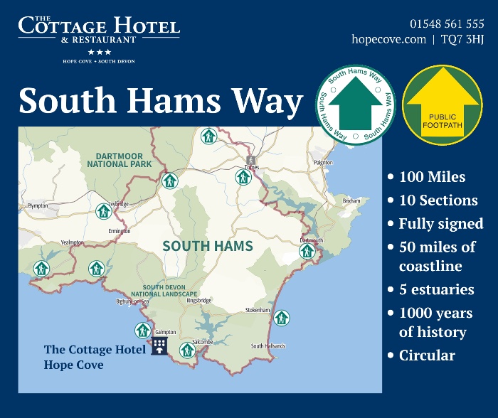
The South Hams Way is a new 100 mile trail allowing the hiker to explore the coast path, Dartmoor national park and the South Devon Natural Landscape all from one circular route.
The walking route is divided into ten sections with the first section beginning in the popular town of Totnes. Each section is roughly ten miles long and are orientated around convenient transport links, refreshments and accommodation so that walkers can do the trail a section at a time if they wish.
The Cottage Hotel at Hope Cove is at the very end of section 6 'Wonwell to Hope Cove'. Hope Cove is roughly speaking about half way round the South Hams Way on the south west coast path section of the route.
The route shares paths with a number of local trails including the Abbots Way, Two Moors Way and more but is clearly signposted all the way around. The route launched on the 14th of September 2025 at an event in Totnes.

The new route has been supported by Visit Totnes, South Hams District council, Kingsbridge Town Council and Ramblers.
Features Along The New South Hams Way
The South Hams Way offers walkers an extraordinary variety of landscapes, landmarks, and cultural highlights across its 100-mile circular route. Whether you're doing the full trail or tackling it section by section, there’s something special to discover around every bend.
You’ll enjoy 50 miles of the spectacular South West Coast Path, stretching from Noss Mayo in the west to Salcombe and Dartmouth in the east. This stretch of coast delivers everything from rugged cliffs and hidden coves to sweeping sea views and sandy beaches.
Inland, the route sweeps into the wild expanses of Dartmoor National Park, where the terrain transforms dramatically into granite tors, open moorland, and ancient woodlands. It’s like stepping into another country entirely—a peaceful contrast to the coastal sections.
Much of the route winds through the South Devon National Landscape, a region of rolling green hills, deep wooded valleys, and quiet country lanes. Native hardwood forests and winding rivers—such as the Erme, Avon, and Dart—link the moors to the sea, offering both scenic variety and ecological richness.
Walkers will also pass by five beautiful estuaries, each with its own distinct character:
-
The Yealm at Noss Mayo
-
The Erme at Mothecombe
-
The Avon at Bantham
-
The Kingsbridge-Salcombe Estuary
-
The Dart at Dartmouth
Beyond the natural beauty, the South Hams Way is rich in history and culture. The trail passes through numerous historic villages, hamlets, and market towns, where a thousand years of history can still be seen in the architecture and street layouts. Highlights include Totnes, the official starting point of the trail, known for its vibrant independent shops, listed buildings, and Norman motte-and-bailey castle.
Whether you're drawn to coastal adventures, inland exploration, or a sense of connection with local heritage, the South Hams Way offers an unforgettable walking experience through one of the most beautiful regions in England.
Ten Sections, Three Distinct Areas
The route takes in some of the UK's most beautiful landscapes. Dartmoor National Park, The South Devon Coastline and the South Devon Natural Landscape (formerly known as an area of outstanding natural beauty).
The area known as the South Hams reaches from Buckfastleigh in the North to Salcombe estuary in the south and Dartmouth in the East to Newton Ferrers in the West. The South Hams Way essentially circles around the entire South Hams area taking in some of the areas most famous attractions such as the South Devon Railway, the River Dart, Royal Navy College, Hope Cove and the famed landscapes of Dartmoor.
Here is an overview of the ten sections that make up the South Hams Way:
Section 1: Totnes to Buckfastleigh
Distance: 7.1 miles | Difficulty: Moderate | Ascent/Descent: 617 / 548 ft
This opening section of the South Hams Way begins in the vibrant town of Totnes, winding along riverside paths, woodland tracks and quiet lanes as it climbs gently toward Dartington Estate, a historic site offering cafes, gardens and cultural attractions.
Walkers pass through North Wood, a tranquil ancient woodland where deer may be spotted, before descending toward Staverton and its heritage steam railway station. A short riverside walk leads onward past rolling fields and farm tracks near Riverford Farm, before ascending toward Buckfastleigh, nestled at the edge of Dartmoor.
The route offers a scenic mix of natural beauty and cultural interest, with options for refreshments and facilities throughout, making it a rewarding introduction to the South Hams Way.
Section 2: Buckfastleigh to South Brent
Distance: 8.9 miles | Difficulty: Strenuous | Ascent/Descent: 1175 / 787 ft
This challenging section leads walkers from the historic streets of Buckfastleigh into the heart of Dartmoor National Park, offering dramatic shifts in terrain and breathtaking moorland views. The route shares part of its path with the Dartmoor Way and crosses a mix of wooded valleys, quiet farmland, and open moor.
A highlight of the walk is the peaceful Avon Reservoir, reached after a steady climb via Water Oak Corner. The path then follows the reservoir’s shoreline to Shipley Bridge, a popular moorland gateway with picnic spots and seasonal refreshments.
From Shipley Bridge, the trail descends through ancient woodlands and across pretty streams, passing through small hamlets like Didworthy and Lutton before arriving in the bustling village of South Brent, nestled at the foot of the moor.
Section3: South Brent to Ivybridge
Distance: 7.1 miles | Difficulty: Strenuous | Ascent/Descent: 971 / 1171 ft
This strenuous and rewarding stretch leads walkers from the historic centre of South Brent, through shaded riverside paths and ancient lanes, up onto the open expanses of Dartmoor. After crossing fields and quiet country roads, the route climbs steeply to the granite outcrop of Ugborough Beacon, offering stunning 360° views across the moor and surrounding South Hams countryside.
The descent takes you past prehistoric landmarks such as Cuckoo Ball and down to the disused Redlake Tramway, a relic of Dartmoor’s industrial past. From here, the path curves down into Ivybridge, once home to the historic Stowford Paper Mill and named after the charming 16th-century ‘Ivy Bridge’ crossing the River Erme.
The section ends at The Watermark Centre, a modern community hub with a library, café, and cinema—offering a well-earned rest stop for walkers completing this dramatic moorland leg of the trail.
Section 4: Ivybridge to Noss Mayo
Distance: 11.9 miles | Difficulty: Moderate | Ascent/Descent: 991 / 1178 ft
This long and varied section leaves Ivybridge following the Erme-Plym Trail alongside the River Erme, through parkland, sports grounds, and open countryside. The route passes historic features like Ermington’s Crooked Spire, with optional detours to the village for refreshments, before continuing through farmland and woodlands with glimpses of the elegant Flete Estate and castle turrets.
After crossing Sequer’s Bridge on the busy A379, the trail continues through quiet lanes and fields, eventually reaching the charming village of Yealmpton—an ideal spot for a rest stop with shops and pubs nearby. From here, the South Hams Way leaves the Erme-Plym Trail, winding along country tracks, pastures, and woodland paths, climbing gently to viewpoints with distant Dartmoor vistas.
The final stretch descends into the wooded Yealm Valley and on towards the picturesque waterside village of Noss Mayo, finishing at Bridgend beside Newton Creek—a perfect halfway stop before the coastal sections of the route begin.
Section 5: Noss Mayo to Mothcombe
Distance: 10.3 miles | Difficulty: Strenuous | Ascent/Descent: 1352 / 1319 ft
This dramatic coastal section follows the South West Coast Path from Noss Mayo to Mothecombe, offering some of the most breathtaking sea views on the South Hams Way. Beginning beside Newton Creek, the trail winds past charming estuary inns, wooded paths above the Yealm River, and historic cottages before climbing onto The Warren, a headland with sweeping views across the English Channel.
Walkers continue east past Gara Point and Stoke Beach, with options to explore ruins like St Peter the Poor Fishermanchurch or divert inland to avoid steep climbs. The path meanders past Beacon Hill and Meadowsfoot Beach, then descends to Mothecombe, a peaceful sandy beach and slipway at the mouth of the River Erme.
If tide conditions allow, walkers may wade across the Erme Estuary to reach the next section—otherwise, a long diversion inland is required. Check tide times before setting out.
Section 6: Wonwell to Hope Cove
Distance: 10.1 miles | Difficulty: Strenuous | Ascent/Descent: 1745 / 1759 ft
This spectacular section hugs the South West Coast Path from Wonwell to Hope Cove, offering a rugged and rewarding stretch with continuous sea views, dramatic cliffs, and sandy coves. Starting at the Erme Estuary, the path follows the coast past Westcombe Beach, Ayrmer Cove, and into Challaborough, with Burgh Island's iconic Art Deco hotel visible ahead.
From Bigbury-on-Sea, walkers enjoy panoramic views before following the cliff-top path to the River Avon crossing at Cockleridge Ham. A seasonal ferry operates here, but when unavailable, a lengthy diversion inland via Aveton Giffordis required to reach Bantham.
The final part of the section winds past Thurlestone Rock, South Milton Sands, and a nature reserve, before arriving at the charming seaside village of Hope Cove, marked by the former lifeboat station and a cluster of thatched cottages in Inner Hope—the perfect place to rest halfway through the trail.
Section 7: Hope Cove to Salcombe
Distance: 8.1 miles | Difficulty: Strenuous | Ascent/Descent: 1056 / 1050 ft
This section follows the South West Coast Path from the thatched cottages of Hope Cove to the sailing haven of Salcombe, taking in some of South Devon’s most iconic headlands and sea views. The route begins with a climb to Bolt Tail, the site of an Iron Age fort, before traversing open headland at Bolberry Down—a scenic and partially accessible stretch managed by the National Trust.
From there, walkers descend steeply to Soar Mill Cove before continuing a rugged and dramatic cliffside walk to Bolt Head, with sweeping views east toward Prawle Point. The route skirts the scenic Starehole Bay, offering glimpses of Salcombe across the estuary and passes the site of the tragic 1916 lifeboat disaster.
After a stop at South Sands (with a seasonal ferry option), the trail leads past North Sands and along Cliff Road into bustling Salcombe, where the ferry at Jubilee Pier marks the end of this leg—and the gateway to the peaceful beauty of East Portlemouth on the opposite shore.
Section 8: East Portlemouth to Torcross
Distance: 13 miles | Difficulty: Strenuous | Ascent/Descent: 1798 / 1824 ft
This rugged and dramatic section of the South Hams Way follows the South West Coast Path from East Portlemouth to Torcross, tracing high cliffs, remote coves, and historic landmarks along South Devon’s wildest coastline.
From the Mill Bay ferry landing, the path winds through scenic clifftops to Gara Rock and descends to the isolated Rickham Sand, before tackling a narrow and exposed route toward Prawle Point—the southernmost tip of Devon and home to a Coastwatch station with panoramic sea views.
The trail continues past secluded coves, WWII bunkers, and seal-spotting headlands toward Start Point, crowned by its iconic lighthouse. From here, walkers enjoy views of Start Bay, passing the ghost village of Hallsands, lost to the sea in 1917.
The final stretch skirts the shingle shores of Beesands and descends through rolling fields to Torcross, where the Exercise Tiger Memorial stands as a poignant tribute to the US servicemen who lost their lives during D-Day rehearsals. It's a stirring end to one of the most scenic and historic sections of the South Hams Way.
Section 9: Torcross to Dartmouth
Distance: 10.7 miles | Difficulty: Strenuous | Ascent/Descent: 1542 / 1184 ft
This scenic stretch follows the South West Coast Path from Torcross to the historic naval town of Dartmouth, taking in nature reserves, secluded coves, and dramatic headlands along the way.
The trail begins beside Slapton Ley, a freshwater lake and nature reserve separated from the sea by the shingle ridge of the Slapton Line. From Strete Gate, the path climbs through fields and woodlands to reveal sweeping views of Start Bay, passing through Strete and down to the popular beach at Blackpool Sands.
After climbing inland through Stoke Fleming, walkers rejoin the coast at Little Dartmouth, with panoramic views to the Daymark tower near Kingswear. The path dips through wooded valleys and clifftop paths, leading to Dartmouth Castleand the estuary mouth.
From here, it’s a pleasant walk along Warfleet Road, past Bayard’s Cove Fort, and into Dartmouth town centre, with its bustling harbour, museums, shops, and riverside cafés. The section ends at the A379 bus stop, but offers plenty of opportunities to explore, rest, or cross the River Dart by ferry to Kingswear.
Section 10: Dartmouth to Totnes
Distance: 13.4 miles | Difficulty: Strenuous | Ascent/Descent: 1768 / 2096 ft
The final section of the South Hams Way leaves the coast behind and winds inland along tranquil lanes, woodland tracks and riverside paths, linking the historic towns of Dartmouth and Totnes. Much of this route follows parts of the Dart Valley Trail and John Musgrave Trail, offering a peaceful contrast to the coastal stages.
From St Clements Church, the trail skirts Old Mill Creek, then climbs through the Raleigh Estate, offering fine views of the River Dart and the open sea, before descending into the picturesque village of Dittisham. A series of green lanes, fields and wooded tracks lead you through Cornworthy, down to the wildlife-rich banks of Bow Creek, and onward to Tuckenhay and Ashprington, with its 14th-century church and estate cottages.
The final miles follow the River Dart past the Sharpham Estate, with optional detours through woodland or along National Cycle Route 28. Arriving in Totnes, the route meanders through the historic town centre—passing the castle, St Mary’s Church, and Market Square—before ending at Borough Park, close to Totnes Railway Station and the South Devon Railway steam line.
This leg is rich in riverside charm, local history, and countryside serenity—a beautiful way to complete your 100-mile journey around the South Hams Way.