
The South Devon National Landscape is an area of outstanding natural beauty protected by law. The area covers much of South Devon from the River Dart in the east to the Yealm in the west protecting both coastal, estuary and inland landscapes.
In 1960, the South Devon area of outstanding natural beauty was first designated and is now one of a family of just 46 national landscapes in Britain. The protected landscape seeks to ensure our peaceful countryside, rugged coastline, rolling hills, picturesque villages, colourful hedge banks, wooded valleys and secretive estuaries are preserved for the enjoyment of all who seek them.
Visiting the Protected Landscape
If you are here on holiday and want to visit the South Devon National Landscape, you will not be disappointed because there is plenty to see and do. Fortunately Hope Cove is right in the centre and is one of those very welcoming local communities in which you'll find accommodation and hospitality to facilitate your exploration of South Devon.
Here's our guide to the South Devon aonb which you can dip in and out of as you see fit:
1. The Coast
There are approximately 94km (~58 miles) of coastline in the landscape so there is no shortage of walking by the sea. All of the coast is made accessible by the South West Coast Path which runs right in front of The Cottage Hotel at Hope Cove.
Along the way you'll find coastal grasslands, rugged cliffs, sea arches, sandy coves, salt marshes and expansive panoramic views of the whole seascape before you.
There are no less than 68 beaches in the South Devon Natural Landscape.
2. Historic Natural Beauty
The South Devon National Landscape is not only defined by its coastline but also by its rich history woven into the land itself. Ancient oak woodlands still cloak sheltered valleys and riverbanks, with some of the best examples found in the Dart Valley near Dittisham and Stoke Gabriel, and along the wooded creeks of the River Yealm. These 'temperate rainforests' are alive with mosses, lichens, and birdlife, offering a glimpse into what much of Britain's woodland once looked like.
The National Trust plays an important role in safeguarding many of South Devon's historic features. Sites such as Coleton Fishacre, the 1920s country home of the D'Oyly Carte family near Kingswear, and Greenway, Agatha Christie's riverside retreat on the Dart, are both in National Trust care and open to the public. Their preservation ensures visitors can connect not just with nature, but with the cultural and architectural heritage of the region.
Scattered across the landscape are reminders of even older histories. From Iron Age hill forts such as Burgh Island and Bolt Tail, to ancient field systems still visible in the patchwork of farmland, South Devon's archaeology reveals centuries of human connection to the land. You'll also come across medieval churches, historic farmsteads, and hidden ruins tucked into the valleys, each telling its own story of how people have shaped and been shaped by this remarkable landscape.
Whether you wander through ancient woods, step into a stately home, or pause beside a weathered stone wall, the historic beauty of South Devon is ever-present layered into the landscape as deeply as its rolling hills and secretive estuaries.
3. Food and Farming
Farming has shaped the South Devon National Landscape for centuries, creating the patchwork of fields, hedge banks, and rolling pastures that define much of its character today. Local communities continue to farm the land, balancing tradition with modern sustainability. Sheep, cattle, and dairy farming are common, while the fertile valleys and sheltered slopes also support crops, orchards, and market gardens.
For many farming families, the designation of the area as a protected landscape is both a responsibility and an opportunity. The emphasis on conservation and sustainable practices helps ensure that future generations can continue working the land while protecting its natural beauty. Many farms have diversified, opening their gates to visitors with farm shops, local produce markets, and seasonal food festivals that celebrate South Devon's bounty. This farm-to-table ethos is at the heart of many of the area's pubs, cafés, and restaurants, where menus are filled with locally reared meat, freshly caught seafood, and homegrown vegetables.
Parts of the landscape are recognised as Sites of Special Scientific Interest (SSSIs), protecting rare habitats and species that thrive alongside working farmland. Traditional hedge-laying, wildflower meadows, and low-intensity grazing all help maintain biodiversity while keeping the countryside productive. These practices not only safeguard wildlife but also contribute to the very outstanding natural beautyor which South Devon is renowned.
Farming here is more than an industry - it is a way of life, supporting close-knit rural communities and connecting visitors to the land through its food, traditions, and landscapes.
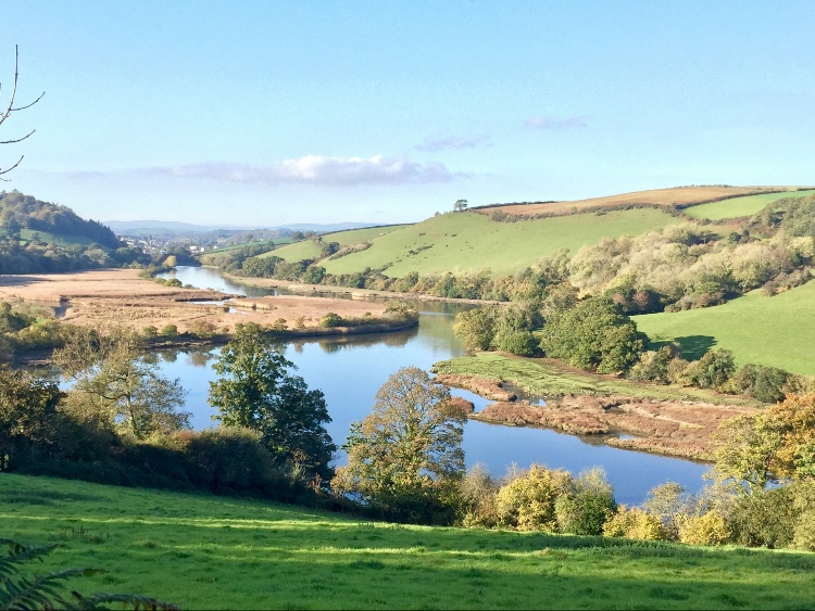
The Five Estuaries
One of the defining features of the South Devon National Landscape is its network of five beautiful estuaries. Each has its own unique character, shaped by the tide, the land, and centuries of human use, and all are rich in wildlife, history, and opportunities to explore.
The five estuaries are:
The Dart
Flowing past Dartmouth and Totnes, the Dart is perhaps the most famous of South Devon's estuaries. It is wide, wooded, and deeply atmospheric, with ancient oak forests lining its upper reaches. Visitors can enjoy boat trips from Dartmouth to Totnes, passing Agatha Christie's former home at Greenway and spotting kingfishers, herons, and even seals.
The Salcombe - Kingsbridge Estuary
Known locally simply as 'the Salcombe Estuary,' this is in fact a ria, a drowned river valley. With golden sandy beaches, hidden creeks, and the bustling town of Salcombe at its mouth, it is one of the most picturesque estuaries in the country. It's a haven for sailing, paddleboarding, and spotting wading birds in the quieter upper reaches near Kingsbridge.
The Erme
Much quieter and less developed, the Erme Estuary feels like a hidden treasure. Accessible at low tide from Mothecombe Beach, the estuary is surrounded by unspoilt countryside and is a designated Site of Special Scientific Interest (SSSI). Wildlife thrives here, and its tranquility offers a very different experience to the busier estuaries nearby.
The Avon
Flowing into the sea at Bantham, the Avon Estuary is framed by rolling farmland and sandy banks. Popular with walkers and birdwatchers, it offers peaceful footpaths along its edges. Canoeing and kayaking are great ways to experience the estuary from the water, with the chance to see curlews, redshanks, and other estuarine birds.
The Yealm
South of Plymouth, the Yealm Estuary is a sailor's favourite, dotted with moorings and pretty villages like Newton Ferrers and Noss Mayo. The wooded creeks are a delight to explore, whether on foot or by boat, and the Yealm supports a wide range of marine life, including shellfish and migratory fish.
Together these five estuaries form a mosaic of natural beauty and cultural heritage. They offer something for everyone: quiet birdwatching, adventurous kayaking, scenic walks, or simply soaking up the atmosphere of tide and time.
More Information on South Devon's Outstanding Beauty
South Devon is one of just 46 National Landscapes (formerly known as Areas of Outstanding Natural Beauty) across England, Wales, and Northern Ireland, forming a vital network for conservation and community well-being. These designations reinforce a shared national identity and advocacy for funding and environmental action. Read more on the National Landscapes website.
What Makes South Devon Special?
The entire coastal fringe holds county-level coastal preservation status, and many cliff-top areas have been acquired by the National Trust to safeguard views and ecosystems. The area also contains numerous Sites of Special Scientific Interest (SSSIs), underlining its ecological significance.
The official site for South Devon National Landscape offers a wealth of updates and practical tools to help visitors and locals engage with the area:
-
Interactive maps, downloadable walks (complete with directions, maps, wildlife, and heritage info), and ferry timetables make planning easy.
-
The site details the Partnership managing the landscape, their Management Plan, local farming opportunities, Special Qualities, and Estuary Management Plans for each of the five estuaries.
-
Recent and ongoing projects are showcased, including Farming in Protected Landscapes initiatives and the Life on the Edge restoration programme.
These resources strengthen both conservation and community connection - bridging nature, heritage, and visitor experience.